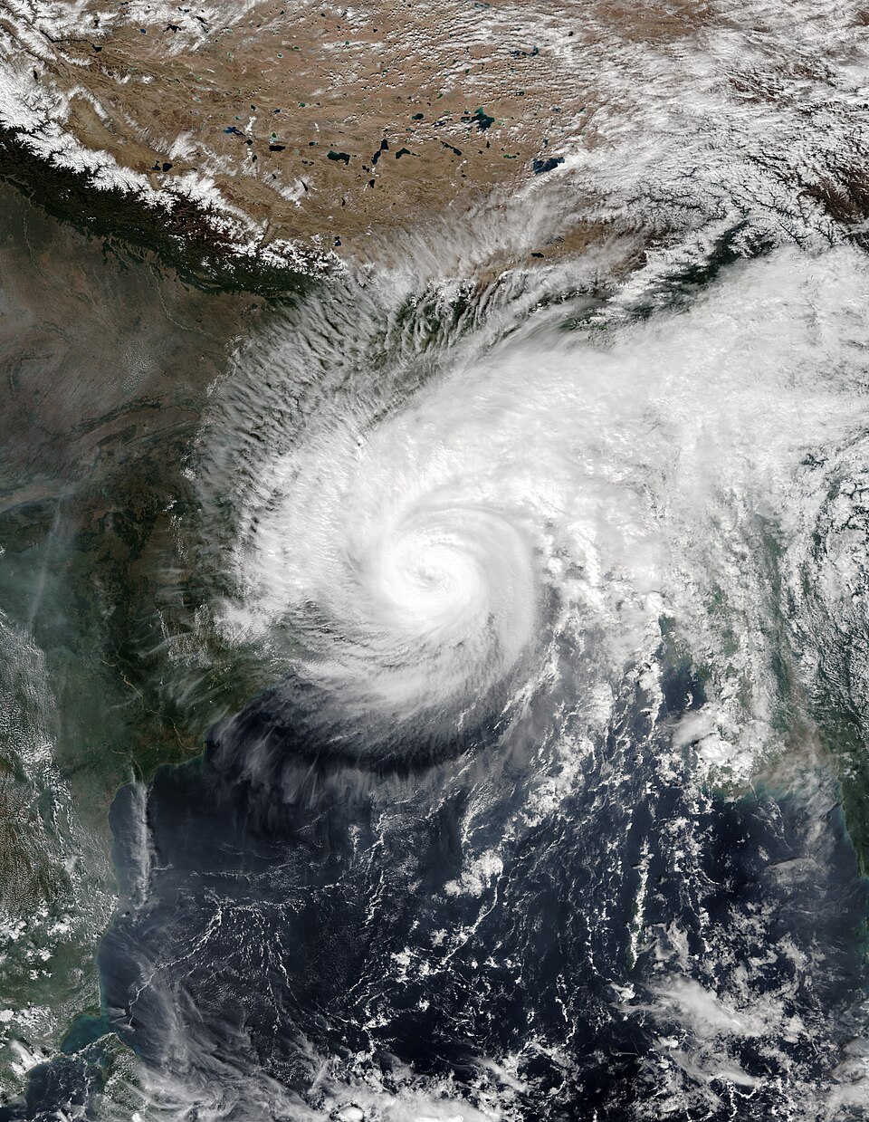
A low-pressure system over the Bay of Bengal is gathering strength on a track towards India's east coast, and forecasters now expect it to peak as a very severe cyclonic storm before crossing the Andhra Pradesh coast on the morning of Wednesday, October 28, bringing destructive winds, torrential rain and rough seas to one of the most cyclone-prone stretches of coastline in the world.
The India Meteorological Department (IMD) said on Saturday that the well-marked low-pressure area was expected to develop into a depression during the day, then deepen into a deep depression on Sunday, October 25, and into a cyclonic storm over the west-central Bay of Bengal by Monday morning, according to The Hindu.
From there, the forecast steepens: a severe cyclonic storm by October 27, and a very severe cyclonic storm by the morning of October 28, when it is expected to cross the Andhra Pradesh coast — and the adjoining Yanam coast — between Bapatla and Visakhapatnam, around 11:30 a.m. local time. At landfall, sustained winds are expected to reach 115–125 km/h, gusting to 140 km/h.
A textbook intensification — and a narrow window to prepare
The system's forecast path leaves coastal authorities with roughly three days between the first depression and landfall, a window both states are using to move people, equipment and supplies into place. Warm sea surface temperatures of 29–30°C and support from the Madden-Julian Oscillation — a large-scale pulse of tropical rainfall that can supercharge storm development — are creating highly favourable conditions for intensification, meteorologists noted, as reported by AP7AM.
Most global weather models agree on the broad picture: a track towards the Andhra Pradesh coast and steady strengthening. A minority of models suggest a possible drift towards Odisha or Tamil Nadu, but with lower probability — a reminder that cyclone tracks can still shift, and that the official forecast will be refined with every bulletin.
On Saturday the system was centred about 820 km south-east of Visakhapatnam and 910 km from Kakinada, and the IMD issued a pre-cyclone watch for the coastal areas of Andhra Pradesh and Yanam. Fishermen have been advised not to venture into the sea until October 29, and authorities are monitoring returning fishing boats.
Odisha: "zero casualties" is the stated goal
Odisha, which lies just north of the forecast landfall zone and has borne the brunt of some of India's deadliest cyclones, moved first. Disaster Management Minister Suresh Pujari said the state government had already taken all precautionary measures, with the goal of "zero casualties", according to The Telegraph.
All 30 districts have been put on alert, collectors of 16 coastal and southern districts have been advised to take precautionary measures, and leave has been cancelled for government employees in Ganjam, Gajapati, Puri and Khurda districts. District collectors have been authorised to decide on the closure of schools and colleges in their jurisdictions.
In Cuttack, puja committees have been asked to immediately remove the decorative bamboo structures erected for Durga Puja — a detail that captures how the storm is colliding with festival season, when temporary structures and large crowds are common across the region.
Andhra Pradesh: reservoirs, rain and readiness
In Andhra Pradesh, Chief Minister N. Chandrababu Naidu directed officials to remain alert for heavy rain and to fast-track irrigation works, asking them to use the expected rainfall in coastal Andhra and Rayalaseema to fill reservoirs and irrigation tanks. "Remain alert and take precautionary measures in view of heavy rainfall likely under the influence of a developing cyclone over the Bay of Bengal," he said in a statement issued late on Friday.
The dual character of the warning — danger on the coast, but badly needed water inland — is typical of Bay of Bengal cyclones, which can devastate shorelines while replenishing the reservoirs that millions of farmers depend on. The balance between those two outcomes will depend on exactly where the storm crosses the coast and how much rain it drops inland as it weakens.
Why the Bay of Bengal breeds such powerful storms
The Bay of Bengal is one of the world's most dangerous cyclone basins, not because its storms are the strongest on Earth, but because of what lies in their path: low-lying, densely populated deltas and coastal plains where storm surge can travel far inland. The 1999 Odisha super cyclone killed around 10,000 people; Cyclone Phailin in 2013, by contrast, killed far fewer after one of the largest peacetime evacuations in Indian history — a shift that explains why both Odisha and Andhra Pradesh now treat early preparation, rather than post-storm relief, as the core of their strategy.
This storm's forecast intensity — very severe, the second-highest category on the IMD scale — puts it in the range where roofs can be torn off, power lines brought down and coastal flooding becomes a serious risk, even with a well-executed evacuation. The 140 km/h gusts forecast at landfall are strong enough to uproot trees and damage kutcha houses, which is why the authorities' emphasis on moving people out of vulnerable coastal settlements before Wednesday matters more than any single forecast detail.
What to watch in the next 48 hours
The next two bulletins will be decisive. If the system becomes a cyclonic storm by Monday morning as forecast, the IMD will begin issuing more frequent, more specific warnings, including the expected storm surge height and the districts most at risk. A shift in track — even by 100 km — could move the worst of the impact from Andhra Pradesh into Odisha, or vice versa, and residents along the entire coast from Tamil Nadu to Odisha should treat the current forecast as a range, not a pinpoint.
For now, the message from both states is consistent: stay alert, follow official instructions, keep away from the sea, and do not wait until Wednesday morning to act. The storm is still three days out — which is precisely when preparation is cheapest and most effective.
Related coverage: the Pacific's own recent seismic scare is covered in Twin Earthquakes Strike Off Vanuatu, and the region's experience with extreme-weather flooding in Bangkok Floods at Breaking Point.
Frequently Asked Questions
When will the cyclone hit the Andhra Pradesh coast?
The IMD expects the system to cross the Andhra Pradesh coast between Bapatla and Visakhapatnam on the morning of Wednesday, October 28, around 11:30 a.m. local time, as a very severe cyclonic storm.
How strong will the winds be at landfall?
Sustained winds of 115–125 km/h are forecast at landfall, with gusts reaching up to 140 km/h, along with heavy rainfall and high sea waves along the affected coast.
Which areas are on alert?
All 30 districts of Odisha are on alert, with 16 coastal and southern districts advised to take precautionary measures, and a pre-cyclone watch is in force for the coastal areas of Andhra Pradesh and Yanam. Fishermen have been advised against entering the sea until October 29.
How does the storm develop over the coming days?
The system is expected to become a deep depression on October 25, a cyclonic storm by October 26, a severe cyclonic storm by October 27, and a very severe cyclonic storm by the morning of October 28.