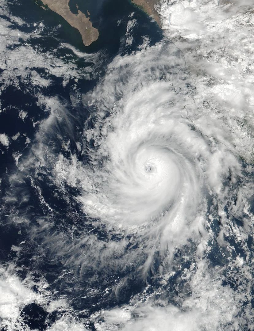
Hurricane Simon has rapidly strengthened into a powerful Category 4 hurricane, with maximum sustained winds reaching 225 km/h, as it barrels toward Mexico's Pacific coast — threatening life-threatening flooding and mudslides across parts of Jalisco, Michoacán, Colima and Nayarit.
The intensification marks Simon as a major hurricane and a serious new threat in a turbulent 2026 season that has already seen the season's first Atlantic hurricane batter the US Gulf Coast this weekend.
Table of Contents
- A Category 4 threat
- Mexico's coast braces for impact
- Life-threatening flooding and mudslides
- A season of unusual storms
- The wider Pacific picture
- Key takeaways
- Frequently Asked Questions
- Sources
- Read more on Chronicle
A Category 4 threat
Simon crossed the major-hurricane threshold early on Saturday as its maximum sustained winds increased to 225 km/h (140 mph), according to reports citing forecasters. A storm of that strength or greater is classified as a major hurricane, capable of catastrophic damage to coastal communities.
The rapid strengthening echoes the pattern seen elsewhere this season: warm ocean waters are giving storms more energy to intensify quickly before landfall, narrowing the window for communities to prepare.
Mexico's coast braces for impact
Simon is expected to bring heavy rainfall over parts of southwestern Mexico, possibly concentrated along the coast of Jalisco and in parts of Michoacán, Colima and Nayarit. These states are no strangers to Pacific hurricanes, but a Category 4 landfall represents the upper end of what the region can absorb.
Authorities in the threatened states typically respond by opening shelters, suspending classes, and advising residents in low-lying and landslide-prone areas to evacuate pre-emptively — measures that take on added urgency when a storm strengthens this fast.
Life-threatening flooding and mudslides
Beyond wind damage, the gravest danger from Simon is water. Forecasters have warned of life-threatening flooding and mudslides as the storm dumps torrential rain over coastal and mountainous terrain. Much of Mexico's Pacific coast combines steep topography with informal hillside settlements, a combination that has repeatedly turned heavy rain into deadly slides.
Even after the center passes, rainfall and flash flooding can persist for days, and officials urge residents not to let their guard down once the strongest winds ease.
A season of unusual storms
Simon's arrival comes as Hurricane Isaias made landfall on the US Gulf Coast as a Category 2 storm — the first hurricane of the 2026 Atlantic season, and reportedly the latest first-hurricane formation in the Atlantic basin in over a century. Meanwhile, another tropical storm, Rachel, was expected to bring strong winds and rain to northern Mexico and Southern California over the weekend.
The result is a genuinely unusual stretch: two named storms simultaneously menacing Mexico from both sides, plus a late-forming first Atlantic hurricane — a reminder that storm seasons no longer follow the old scripts.
The wider Pacific picture
The eastern Pacific has historically been one of the most active hurricane basins in the world, and Mexico's Pacific coast sits squarely in its path. Climate scientists have warned that warming oceans are not only making storms more likely to intensify rapidly, but also increasing the amount of rain they carry — the factor behind most hurricane fatalities worldwide.
Key takeaways
- Hurricane Simon has strengthened into a Category 4 storm with sustained winds of 225 km/h.
- The storm is barrelling toward Mexico's Pacific coast, threatening Jalisco, Michoacán, Colima and Nayarit.
- Forecasters warn of life-threatening flooding and mudslides from torrential rainfall.
- Simon arrives amid an unusual season: Isaias just hit the US Gulf Coast while Tropical Storm Rachel targets northern Mexico.
Frequently Asked Questions
What does Category 4 mean on the hurricane scale?
Category 4 on the Saffir-Simpson scale means sustained winds of 209–251 km/h (130–156 mph), capable of catastrophic damage: destroyed roofs, snapped power infrastructure, and a high risk of life-threatening storm surge and flooding in coastal areas.
Which parts of Mexico are most at risk from Simon?
Heavy rainfall is expected over parts of southwestern Mexico, concentrated along the coast of Jalisco and in parts of Michoacán, Colima and Nayarit, with flooding and mudslide risks extending inland over mountainous terrain.
Is Simon related to Hurricane Isaias?
No — they are separate storms. Isaias was the first Atlantic hurricane of the 2026 season and made landfall on the US Gulf Coast near Destin, Florida, on Friday. Simon is an eastern Pacific hurricane threatening Mexico independently.
Why are forecasters worried about mudslides in particular?
Much of Mexico's Pacific coast combines steep mountainous terrain with dense hillside communities. Torrential tropical rainfall on such slopes can quickly trigger deadly mudslides, even in areas far from the storm's center.
Sources
- Al Jazeera English — reporting on Simon's Category 4 intensification toward Mexico's coast
- Arab News — Isaias landfall on the US Gulf Coast