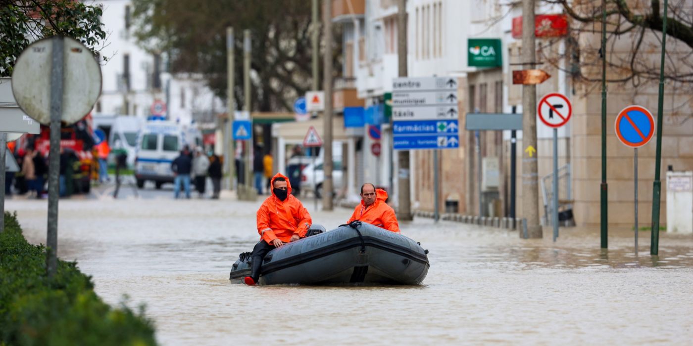
Storm Charles has brought destructive weather to southern Europe this week, flooding streets in Portugal and Spain, grounding hundreds of flights, closing thousands of schools and forcing one of the world's biggest technology conferences to suspend its programme. The storm first struck the Portuguese island of Madeira with winds of 136 km/h, then swept across the Iberian mainland on Wednesday before tracking north-east through southern France towards northern Italy.
The scale of the disruption underlines how exposed Europe's busiest travel corridors have become to autumn storms. Lisbon airport alone cancelled 183 flights on Wednesday — around a third of its normal daily traffic — while Madrid's Barajas airport cancelled 155, and airports across Portugal and the Canary Islands reported dozens more. For travellers, the storm turned a routine midweek journey into days of uncertainty; for emergency services, it became a test of flood defences that have been repeatedly strained in recent years.
Madeira hit first
Heavy rain and strong south-westerly winds arrived first in Madeira, the Portuguese island in the Atlantic, before the system headed towards the mainland on 11 November. A wind gust of 84.5 mph (136 km/h) was recorded at Funchal airport, alongside rainfall totals reaching 355mm in just 12 hours — more than many parts of the island would normally expect in a month.
The deluge uprooted trees and triggered severe flash flooding across the island, according to The Guardian. Emergency crews worked through the night as floodwater swept through streets, and the damage set the tone for what was to follow on the mainland.
Portugal: schools shut, red warning, Web Summit suspended
On the Portuguese mainland, the storm's arrival on Wednesday prompted a rare red weather warning — the highest level — and the closure of thousands of schools. Portugal's Civil Protection service logged more than 500 incidents nationwide by midday on Wednesday, with its commander, Mario Silvestre, confirming that authorities were maintaining high alerts for flash floods, fierce winds and rough seas.
The disruption reached into the heart of Lisbon's business calendar. The Web Summit, the massive technology conference attended by 70,000 people, was forced to cancel its proceedings for the day as the storm battered the capital. Portugal's state weather agency, IPMA, recorded gusts topping 75 mph, and the Algarve tourist region was among the areas hit by the extreme weather.
At Lisbon airport, the 183 cancellations represented about a third of the airport's usual traffic. Across Portugal as a whole, more than 200 flights were cancelled as operations at airports up and down the country ground to a standstill, according to The Sun.
Spain: 260mm of rain, tornado warnings and airport chaos
Spain bore the brunt of the storm's second wave. The country's state weather agency, Aemet, said Puerto El Pico in Avila, near Madrid, was the worst-affected town, recording a staggering 260mm of rainfall in just 36 hours. In Andalusia, the regional government sent urgent ES-Alert mobile warnings to 30 municipalities across Cadiz and Huelva, and an emergency alert warned of a high risk of tornadoes.
Madrid's Barajas airport cancelled 155 flights — about 13% of its traffic — while the Canary Islands were also battered, with 90 mph gale-force winds recorded in exposed areas on Tenerife. Dozens of flights were cancelled at the islands' airports, and video footage showed muddy water cascading down hillsides and fallen trees blocking major roads.
Chronicle has previously reported on severe flooding in Spain, including the October storms that inundated Valencia, a reminder that the Iberian Peninsula has faced repeated extreme-weather events in recent weeks.
France and Italy next in line
After causing widespread flooding in Spain and Portugal, the system moved on a north-easterly track through southern France and then towards northern Italy. Two flights from Nice Côte d'Azur airport were cancelled on Wednesday — the 11:55 departure to Lisbon and a 19:00 flight to Madrid — according to flight-tracking data cited by Connexion France.
Météo-France forecast rain across a large part of southern France, from the Pyrenees and the Mediterranean coast towards Poitou-Charentes, Berry and parts of eastern France. Four departments — Alpes-de-Haute-Provence, Hautes-Alpes, Alpes-Maritimes and Hautes-Pyrénées — were placed under a yellow rain-flood warning, while six more, including Bouches-du-Rhône, Var, Gard, Hérault and Corse-du-Sud, were under yellow alerts for coastal flooding and dangerous waves. The weather was set to improve on Friday, 13 November.
The storm also reached further afield: heavy rain and strong winds caused disruption across British Columbia, Canada, over the last week, a sign of the same restless weather pattern affecting both sides of the Atlantic.
A pattern of stronger autumn storms
Storm Charles is the latest in a series of powerful autumn systems to hit Europe. Forecasters have noted that warmer Atlantic waters can load storms with more moisture, producing the kind of rainfall totals — 355mm in 12 hours in Madeira, 260mm in 36 hours in central Spain — that overwhelm drainage systems built for a milder climate.
For Portugal and Spain, the immediate task is clearing up: reopening schools, restoring cancelled flights and assessing damage to roads, homes and businesses. The longer question is whether infrastructure designed for yesterday's weather can cope with storms that now arrive more often and hit harder. Chronicle also covered a storm warning issued for Greece earlier this month, part of the same unsettled pattern across the Mediterranean.
Key takeaways
- Storm Charles struck Madeira first, with a 136 km/h gust at Funchal airport and 355mm of rain in 12 hours.
- Lisbon airport cancelled 183 flights on Wednesday and Madrid Barajas 155, with more than 200 cancellations across Portugal.
- Thousands of schools closed in Portugal under a rare red warning; more than 500 incidents were logged by midday on Wednesday.
- The Web Summit in Lisbon, attended by 70,000 people, suspended its programme for the day.
- In Spain, Puerto El Pico recorded 260mm of rain in 36 hours, and tornado warnings were issued for parts of Andalusia.
- The storm then tracked north-east through southern France towards northern Italy, with conditions expected to improve on Friday.
Frequently Asked Questions
What is Storm Charles?
Storm Charles is a powerful low-pressure weather system that brought torrential rain and high winds to southern Europe in the week of 9–13 November 2026. It struck Madeira first, then crossed mainland Portugal and Spain, and moved north-east through southern France towards northern Italy.
How many flights were cancelled?
Lisbon airport cancelled 183 flights on Wednesday, around a third of its normal daily traffic, and Madrid Barajas cancelled 155. More than 200 flights were cancelled across Portugal as a whole, with further cancellations in the Canary Islands and at Nice airport in southern France.
Why were schools closed in Portugal?
Portugal activated a rare red weather warning — the highest level — as the storm brought flash-flood risks, fierce winds and rough seas. Thousands of schools were ordered to shut on Wednesday, and the Civil Protection service logged more than 500 incidents nationwide by midday.
What happened at the Web Summit in Lisbon?
The Web Summit, a major technology conference attended by 70,000 people, was forced to cancel its proceedings for the day on Wednesday as Storm Charles battered Lisbon, with high winds and heavy rain disrupting the city.
Where is the storm heading next?
After crossing the Iberian Peninsula, Storm Charles moved north-east through southern France and towards northern Italy. Météo-France issued yellow rain-flood and coastal-flood warnings for departments across the south, with conditions expected to improve on Friday, 13 November.